第44話(2022/10)
Where
Did The Blind Piper Live?
by Bridget MacKenzie
"Piping Times" Vol.45/No.12-1993/9〜Vol.46/No.05-1994/2
"Piping Times" Vol.45/No.12-1993/9〜Vol.46/No.05-1994/2
私が紙版として所有していた "Piping Times" は1977年10月以降の号。当時の "Piping Times" にはピーブロック関連の記事が沢山掲載されていました。特に Seumas MacNeill と Seumas 亡き後その役目を引き継いだ Dughald MacNeill が編集長であった20世紀中はその傾向が特に顕著。30年前の "Piping Times" を振り返る作業を始める際にその 22年間のピーブロック関連記事をリストアップした所、その数はおよそ300件ありました。1977年10月号〜1992年9月号までの "Piping Times" を紹介する中で、その内の150件ほどを紹介した所でした。
さて、残りの150件を含めて22年間のトータル300件の中で、私にとってこれまでダントツ1番に印象的だったのが この記事です。当時、初めて読んだ時は「あ〜、 "Piping Times" 購読していてよかった!」とつくづく感じ入ったものでした。
"Piping Times" のデジタル化がなかったとしたら、30年後の 2023年9月 号から 2024年2月に掛けて3回に分けて紹介する予定になっていましたが、デジタル化によって早々に紹介できる事は嬉しい限 り。デジタル化の恩恵で、自 分で四苦八苦して翻訳&要約する必要もなく、(専門用語やスコットランド特有の単語に関する修正は必要ですが)全文を一 気に日本語化出来てこうやって紹介できるのはナニヨリです。
Ian L. MacKay による1954年6月号の記事等を紹介したパイプのかおり第43話と、この Bridget MacKenzie 女史の1994年の PSカンファレンスに於ける講演録を基にした CANNTAIREACHD - MacCrimmori's Letter No.16 と併せてお読み下さい。
筆者の Bridget MacKenzie 女史はこの記事を書いた5年後の1998年に出版した "Piping Traditions of The North of Scotland"(John Donald Publishers Ltd.)の中で、この記事をベースに Iain Dall MacKay に関する更に充実した情報を書き下ろしています。また、私が1997年に書いた CANNTAIREACHD No.16 に引用したストーリーは、1994年 PSカンファレンスに於ける Bridget MacKenzie 女史の講演録のほんのサワリです。そこには Iain Dall MacKay の生涯、そして詩作とピーブロックに関するディーブなストーリーがてんこ盛り。PSサイト会員の方は、どうか PSサイトにアップされているカンファレンスの講演録をお目通し下さい。(講演録も文字認識テキスト形式になっているので、翻訳ソフトに掛 ければ日本語で読む事が可能です。)
様々な資料を読み解く事によって、ただ一人で全てのマクリモン・パイパーと並び得る希代の天才パイパー、The Blind Piper、Iain Dall MacKay of Gairloch の生涯に想いを馳 せてみて下さい。作者やその作者が作った曲の背景を知る事は、ピーブロックをより一層深く味わう事に繋がります。
| 原 文 |
日本語訳 |
|---|---|
| Part1 【Vol.45/No.12-1993 /9-P17】 |
|
| Until recently, all that was known about the home of Iain Dall MacKay, the Blind Piper of Gairloch, was a tradition that he was born at Talladale, on Loch Maree side (Dixon 307), and that his father Ruaraidh moved to Gairloch from Talladale after the 6th laird, Kenneth MacKenzie of Gairloch, built the Stankhouse, soon after 1638 (Dixon 177; Osgood 191). | つい最近まで、Iain Dall MacKay of Gairloch が暮らした場所について我々が知り得ていたのは、彼が Loch Maree 畔の Talladale で生まれたという伝承(Dixon 307)と、彼の父親 Ruaraidh が、Gairloch の第6代領主 Kenneth MacKenzie が1638年からまもなくして Stankhouse を建設した際に、Talladale から Gairloch へ引っ越したという事だけだった(Dixon 177; Osgood 191)。 |
 |
|
| Already there is an
apparent discrepancy : Iain Dali was born around 1656, certainly no earlier, so if Dixon is correct, possibly Ruaraidh or his brother Donald Mor retained the holding in Talladale after he himself went to live in or near the Stankhouse, at the mouth of what is now known as the Flowerdaleglen. Perhaps he accompanied the chief as his piper, and had no land or house in the glen at that time. Nothing else was known to the piping world about the MacKays' holdings of land or their homes in the period from 1638 until 1805, when Iain Dali's grandson John Roy MacKay took his entire family, except for one married daughter, to Nova Scotia. This was how things stood when Roy Wentworth was appointed Archivist, and then Curator, at the Gairloch Heritage Museum. Roy is a Gaelic speaker with a wide knowledge of the Gairloch district and its placenames. This was one stroke of luck for the piping world. The other was not so obviously a stroke of good luck, especially for the Gairloch estate. In 1984 a violent storm swept up the Flowerdale glen and flattened much of the planted forest of mature conifer trees which had blanketed the whole of the upper glen. For the estate, this meant a long period of clearing up, which is still in progress, the remaining trees being felled and the ground cleared. For the piping world, it meant that for the first time for a century or more it is possible to see the sites, the lie of the ground, the foundations of old structures, and the views. Roy Wentworth set about studying old maps and documents, and obtained access to the Gairloch estate papers in Conon House, near Cononbridge in Easter Ross, very helpfully made available by the laird, John MacKenzie of Gairloch. There he found old rentals, Tutorial Accounts, Judicial Rolls and Minutes of Sett, which gave him many references to the MacKays : John Pyper (as Iain Dall was listed), Angus MacKay the piper (his son), and John MacKay (his grandson). Even the signatures of Angus and John Roy are there - not of Iain Dall himself, of course, since he was illiterate, never taught to read or write because of his blindness. The estate records do not go back into the 17th century, however, but start in the early years of the 18th. They give us a glimpse of the MacKays and their holdings in the hundred years before they left the district. |
既にここには大きな矛盾点がある。 Iain Dall は1656年頃に生またとされ、それ以前には生まれていない事は明白なので、Dixon が正しければ、Ruaraidh あるいは彼の弟 Donald Mor は、現在 Flowerdaleglen として知られる河口の Stankhouse かその近くに引っ越した後も、Talladale の土地を保持した事になる。 おそらく彼は、チーフのお抱えパイパーとして行動したのであって、その時点では glen(Flowedaleglen?)には土地も家も持っていなかった のではなかろうか。 1638年から、Iain Dall の孫の John Roy MacKay が結婚した娘一人を除く家族全員を連れて(カナダ)ノバス コシア州に渡る1805年までの間、MacKay 家が土地や家を所有していた、という事実についてはパイピング界では何も知られていない。 Roy Wentworth が Cairloch Heritage Museum の古文書保管係と学芸員として任命された時も、このような状況だった。Roy はゲール語を話し、Gairloch 地方とその地名について幅広い知識を持っている。これは、パイピング界にとって一つの幸運だった。 もう一つの出来事は、特に Gairloch の地所にとっては、明らかに幸運という訳ではない。1984年、激しい嵐が Flowerdale 渓谷を襲い、渓谷の上部を覆っていた成熟した植栽された針葉樹林の多くがなぎ倒された。このため、この地所では、その後長い時間掛けて作業が行われてい る。現在 もなお、残りの木々が伐採され、地面が整地作業が続いている。 (一方で)パイピング界にとっては(幸いな事に)、100年かそれ以上ぶりにその跡地や地層、古い建 物の基礎、そして景色を眺めることができるようになったのである。 Roy Wentworth は古い地図や文書の研究に着手。Easter Ross の Cononbridge に近い Conon House にある Gairloch の領主 John MacKenzie の好意により、地所に関する文書を閲覧することができた。 彼はそこで、古い賃貸契約書、Tutorial Accounts、司法文書、Minutes of Sett などを見つけ、MacKenzie 家に関する多くの参考文献に目を通す事ができた。 John Pyper (Iain Dallの名前)、Angus MacKay the piper (彼の息子)、John MacKay (彼の孫)など。Angus と John Roy の署名までも確認できた。もちろん、Iain Dall 自身は盲目のため読み書きを教わらなかったので、署名はない。 しかし、領地の記録は17世紀までさかのぼることはできないが、18世紀初頭から始まるので、 MacKay 家がこの地方を去るまでの100年間の、彼らと彼らの借地に関する情報を垣間見ることができる。 |
| The documents make it
clear exactly which holdings the family had at
different times, and what rent they paid. Roy was
able to list them, with the appropriate dates : 1706 - 1711 John Pyper in Brienrie (or Breanrie) paying rent of 27 merks 12 shillings 2 pence in 1705,1706. * He was one of two tenants there. 1711 - 1715 John Pyper in Engidilglass paying £15.5.6d Scots as yearly rent, one of three tenants there. 1716 Jo: Pyper in Engidilglass and John MacPherson in Ritadonell, 2 pecks of land, apparently held jointly for a rent of £30.11s.0d Scots. 1721 Ken: Duncanson and John Pyper in Engadileglass paying £45.16s.6d Scots. The above names and dates come from the Tutorial Accounts for the Gairloch Estate, 1705-22. There is then a gap of 30 years in the Conon House records of rent, from 1722 to 1752. In 1752, Angus MacKay was tenant of Cairbeg (part of Kerrysdale). His father was still living but in his nineties - he died two years later (see below). In 1759, Angus MacKay obtained a tack for 25 years from Sir Alexander MacKenzie, the 9th laird, "as his piper", for land at Cairmore (now a lost name - it may have become part of Flowerdale Farm, or part of Kerrysdale Farm), Cairbeg (Kerrysdale), and the grazing of half of Doirichhin (now known as na Doireachan, above Kerry Falls and west of Loch Bad an Sgalaig, just south of the modern road over to Loch Maree). Angus, according to his grandson in Nova Scotia (Reminiscences 2), was on terms of close friendship with the young future 10th laird for most of his life, and when this laird, also Sir Alexander, was dying in 1770, he would have none but Angus to pray with him and counsel him at his bedside. Angus was a deeply religious man, and well educated, the only one of his family to obtain a tack, thus raising his social status. His son, John Roy, was also an educated and religious man, but he was not a tacksman. Sir Alexander, the 9th laird, died in 1766, and a Judicial Rental was compiled. This lists Angus MacKay as tenant of Cairmore and half of Dirichen.When Sir Alexander, the 10th laird, died in 1770, another Judicial Rental was made, with Angus MacKay as tenant of Cairmore, Cairbeg and half of Dirichen : two pecks of land at Cairmore, two pecks at Cairbeg, as well as the grazing of half Dirichen - "for which he pays yearly Seven pound Nineteen shilling sterling of money rent, half a stone Butter and a stone Cheese, two Weders and one ffat Kid and Carriage Horse to Cononside". He also paid, every fifth year £3.6s.8d. sterling in the name of Grassum or Entry money (paid when a lease was granted or renewed). And he "depones that for past years his Master allowed him in name of Salary as his piper yearly the sum of three pounds four shillings and ninepence sterling, all of which is truth as he shall answer to God... and (he) pays a proportion of the schoolmaster's salary..." In other words, Angus had his cash rent halved, for his services as piper. There is no record of how his father had been rewarded for his services as both piper and bard to the chief, but he may have had a house and/or land in Talladale, rent-free (see below). |
これらの文書類によって、一族がどの時期にどの
ような 土地を所有し、どのような賃料を支払っていたかが明らかになった。Roy
は、以下のように詳細な年月付きでリストを作成した。 1706 - 1711年 Brienrie(またはBrianrie)の John Pyper は、1705年と1706年に 27マルク12シリング2ペンスの家賃を支払う。 彼は2人の賃借人のうちの1人。 1711 - 1715年 Engidilglass の John Pyper が3人の賃借人のうちの1人として、年間家賃 £15.5.6d Scots を支払う。 1716年 Engidilglass の Jo : Pyper と Ritadonell の John MacPherson、が2ペックの土地を 共同で所有し、£30.11s.0d の地代を支払う。 1721年 Engadileglass の Ken : Duncanson と John Pyper が £45.16s.6d Scots を支払う。 上記の名前と日付は、Gairloch Estate, 1705-22 の Tutorial Accounts による。 その後、Conon House の家賃記録には1722年から1752年まで30年の空白がある。 1752年、Angus MacKay は Cairbeg(Kerrysdaleの一部)の借主であった。父親はまだ生きていたが90歳を過ぎてお り、2年後に死亡した(下記参照)。 1759年、Angus MacKay は第9代領主 Sir Alexander MacKenzie から「彼のお抱えパイパーとして」、Cairmore(現在この名は失われているが、恐らく Flowerdale Farm の一部か、Kerrysdale Farm の一部にだと思われる)、Cairbeg (Kerrysdale)、Doirichhin の半分(現在は na Doireachan として知られ、Kerry Falls の上、Loch Bad an Sgalaig の西、Loch Maree へ向かう現代の道路のすぐ南)の土地について25年の tack を取得した。 ノバスコシア州の孫によると(Reminiscences 2)、Angus は生涯を通じて、将来10代目となる若い領主と親交を持ち、1770年にこの領主 Sir Alxander が亡くなる際には、Angus 以外に枕元で一緒に祈り、助言を与える者はなかった。 Angus は信仰心の厚い人物で、教養もあり、一族の中で唯一 tack を手に入れ、社会的地位を高めていた。息子の John Roy も教養と信仰心のある人物だったが、tacksman にはなれなかった。 9代目領主の Sir Alexander は 1766年に亡くなり、司法賃貸契約書が作成された。その中で、Angus MacKay が Cairmore と Dirichen の半分の借主として記載されている。 1770年に第10代 Sir Alexander が 死去すると、Angus MacKay を Cairmore、Cairbeg、Dirichen の半分の借主として、Cairmore に2ペック、Cairbegに2ペック、Dirichen 半分の牧草地を「毎年7ポンド19シリングの家賃、バター半石、チーズ1石、ウェダー(去勢された牡羊)2 頭、肥育馬1頭と Cononside に納める」という新たな司法賃貸契約書が作成された。 彼はまた、5年ごとに Grassum または Entry money(賃借権の付与または更新の際に支払われる)の名目で £3.6s.8d を支払った。 また、「過去数年間、主人は毎年3ポンド4シリング9ペンスをパイパーとして給与の名目で許可し、そのす べては彼が神に答えるべき真実であり、校長の給与の割合を支払っていることを供述する」。 つまり、Angus はパイパーとして奉 仕することで、家賃を半額にされた訳である。 Angus の父親(Iain Dall)が、 パイパー として、また吟遊詩人として、どのような報酬を受けていたかについては記録 がないが、Talladale に家と土地、或は家か土地を無償で借りていたのかもしれない(下記参照)。 |
 |
|
| Angus signed his own
name to the Judicial Rental in a clear, firm hand.
Many of his fellow-tenants had to make their
marks, being unable to write their own names. His
grandson (Reminiscences 2) said he was a good
scholar. There are no MacKays in the Minutes of Sett for 1770, because these record only new tenancies and leases, and Angus had started his 25-year tack in 1759. For the same reason, the 1775 Minutes of Sett name no MacKays. In 1780, however, John MacKay (John Roy) gets a new agreement. He is given the tenancy of 2 pecks of land at Engadaleffuile (Engadal of the Pool), and half a peck of grass at Fasvicenvue (Faich Mhic Eoin Bhuidhe, "Meadow of the son of yellow Eoin"). Angus's holding of Cairmore, Cairbeg and Derrichan now goes to one Alexander Ross, who is described as being already "tenant there". This tells us clearly that Angus MacKay died between 1775 and 1780. His grandson "The Squire" in Nova Scotia confirms this in his "Reminiscences", when he says that Angus died "comparatively young". He would have been in his mid-50's, around 55 years old. Dixon's comment (179) that Angus "lived to a good old age" must be mistaken. Osgood (193) makes the same mistake, almost certainly following Dixon here. |
Angus
は、司法賃貸契約書にはっきりとした手書きで自分の名前をサインしている。多くの借家人は、自分の名前を書くことができないので、自分で印をつけなければ
ならなかった。彼の孫(回想録2)は、彼が優れた学者であったと語っている。 1770年の Minutes of Sett には、MacKays の名前はない。これは、Minutes of Sett には新規の借地権とリースしか記録されておらず、Angus は1759年に25年の契約を開始していたためである。同じ理由で、1775年の Minutes of Sett にも MacKays の名前は無い。 しかし、1780年、John MacKay(John Roy)は新たな契約を結ぶ。彼は Engadaleffuile(プールの Engadal)の2ペックの土地と Fasvicenvue(Faich Mhic Eoin Bhuidhe、「黄色の Eoin の息子の草地」)の半ペックの草地を借用することになったのである。 Angus の Cairmore、Cairbeg、Derrichan の所有権は Alexander Ross に移り、彼はすでに「そこの借主」であったと記述されている。このことから、Angus MacKay は1775年から 1780年にかけて死去したことが明らかになった。ノバスコシア州の彼の孫である "The Squire" は、彼の「回想録」の中で、Angus が「比較的若い」うちに亡くなったと述べており、このことを裏付けている。50代半ば、つまり55歳前後で あったろう。 Dixon のコメント(179)では、Angus は「いい年まで生きた」とされているが、これは間違いであろう。Osgood (193)も同じ間違いを犯してお り、Dixon にほぼ従ったものと思われ る。 |
 |
|
| In the Conon House
Archives, Bundle 46, 19/115, the Gerloch Rental
for Whitsunday 1785 has John MacKay (John Roy) as
Tenant of M(eikle) Talladale, paying rent of
£6.11s.6d. yearly, and £8.8s.0d. for the
five-yearly Grassum or Entry money. Does this mean that the MacKays returned to the old family holding at Talladale, or had they held it all along? If so, why is it not in the earlier estate rentals? Sir Hector MacKenzie seems to have not renewed leases in the "Brae” of Gairloch, near Flowerdale House, from 1785 on. Presumably he wanted the place to himself, free of all tenants. But in spite of Dixon (179) saying "When [John MacKay] went to America, Sir Hector said he would never care to hear pipe music again", Sir Hector was content to have John MacKay miles away in Talladale, where he would hear his piping only quite infrequently, rather than beside him, near to Flowerdale House. Changed times. In an unpublished article on the pedigree of Iain Dali MacKay, which examines a descendant's claim that Iain's grandfather was Lord Reay, John G. Gibson of Nova Scotia has drawn attention to a document quoted in William MacGill's "Old Rossshire and Scotland from the Tain and Balnagowan Documents" (1909), which lists "the tenendrie of Gairloch and yeirlie rent". In the list is Telladill. This deed is undated. It names two brothers, Donald and Rorie, sons of Duncan, as tenants in Telladill, paying rent of £53.6s.8d. Scots. Another tenancy, also in Telladill, has a rent of £103.6s.8d. for 5 pecks of land : the implication is that Donald and Rorie held some 2- 3 pecks of land, not a large holding. MacGill dates the handwriting of the document to the decade 1660-1670, the decade after that of Iain Dall’s birth, said to have been in Talladale. The original document has not been traced, however, and this dating is probably in doubt. The deed is not quoted in full ; if traced, it would possibly give us more information. There is no certainty that these sons of Duncan were the MacKays, uncle and father of Iain Dall, though it does seem likely. The document describes Donald as a "wright" which usually means a carpenter, but could also mean a metal-worker or smith. When Ruaraidh MacKay, Iain Dall's father, came to Gairloch in 1609 as piper to the MacKenzie chief (Dixon 41; Osgood 190), was he given a house and/or some land? As piper to the chief of MacKay in Strathnaver he may well have been part of the chief s household, given free board and lodging for his services. The MacKenzie laird's household was restricted, as he lived on one of the islands in Loch Maree where space was limited - so did he compensate his new young piper by providing him with accommodation? If Dixon (92-3) is correct in saying that Sir George Hay established an iron-smelter at Talladale in about 1607, Ruaraidh would have been able to make a living by cutting trees to make the charcoal which fed the smelting furnace. It would have provided a rare opportunity for employment of a newcomer to the district. I would suggest that possibly the MacKays had either a house or a holding of land at Talladale throughout the years they were in Gairloch. They seem to have been paying rent in the time of Ruaraidh and his brother Donald, but there is no record of their payments after that until suddenly in 1785 John Roy's name appears, paying rent and Grassum. One explanation is that the Blind Piper himself held this tenancy rent-free for his double service as piper and bard - but this does not explain what was happening in Angus' time, when he was receiving reward as a piper in other ways (see above). In the Gairloch Old Parish Register, the birth of a daughter, Margaret, was recorded in 1804, to Colin Fraser, tenant of Talladale, and his wife, Mary MacKay. Mary was a daughter of John Roy, and the Frasers went with her father to Nova Scotia the following year. John Roy is said (Dixon 179; Osgood 194) to have left from Slattadale to go to Nova Scotia, rather than from Talladale. The tenancy of Colin Fraser in 1804 might support this, or the whole family may have been in Talladale at that time. To some extent the names Slattadale and Talladale overlap and are used interchangeably. |
Conon House 公文書,
Bundle 46, 19/115の Gerloch Rental for Whitsunday
1785 には、M(eikle) Talladale の借主として John MacKay (John Roy)が、年間£6.11s.6d
の家賃と5年毎の Grassum または Entry money として£8.8s.0d.
を支払っているとある。 これは、MacKay 家が Talladale の旧所有地に戻ったということなのか、それともずっと所有していたのだろうか。もしそうなら、なぜ以前の地所賃貸料に含まれていないのだろうか。Sir Hector MacKenzie は、1785年以降、Flowerdale House に近い Gairloch の "Brae" での賃貸契約を更新しなかったようである。おそらく、すべての借家人から解放され、自分だけの場所にしたかったのだろう。 しかし、Dixon (179)が「(John MacKay が)アメリカに行ったとき、Sir Hector は2度とパイプ音楽を聞きたくないと言った」と述べているにもかかわらず、John MacKay が Flowerdale Houseの近くにいるのではなく、数マイル離れた Talladale でごくまれにしかパイプを聞かないことに Sir Hector は満足しているようであった。時代は変わった。 ノバスコシア州の John G. Gibson は Iain Dall MacKay の 血統に関する未発表の論文で、Iain の 祖父が Lord Reay であるという子孫の主張を検証し、William MacGill の "Old Rossshire and Scotland from the Tain and Balnagowan Documents" (1909) に引用された文書、「Gairloch と yearlie rent の tenendrie」一覧に注意を促している。 その中に Telladill がある。この証書は年代不明。Duncan の息子 Donald と Rorie という二人の兄弟が Telladill の借主として名を連ね、£53.6s.8d. Scots の賃料を支払っている。同じく Telladill にある別の借地権では、5ペックの土地に £103.6s.8d. の賃料が設定されており、Donald と Rorie は2〜3ペックの土地を所有していたと考えられるが、それほど大きな土地ではないようである。 MacGill は、この文書の筆跡を1660年から1670年の10年間と推定しているが、これは Iain Dall が Talladale で生まれたとされる年の翌年である。しかし、この文書の原本は見つかっておらず、この年代には疑問がある。この証書は全文が引用されていないが、もし追跡 できれば、より詳細な情報が得られるだろう。 この Duncan の息子たちが、Iain Dall の叔父であり父である、MacKay 家であるという確証はないが、その可能性は高いようである。 文書には Donald は "wright" と書かれているが、これは通常大工を意味するが、金属加工職人や鍛冶 職人を意味することもある。 Ruaraidh MacKay, Iain Dall の父親が 1609 年に MacKenzie チーフのパイパーとして Gairloch に来た時(Dixon 41; Osgood 190)、家か土地を与えられたのだろうか? Strathnaver の MacKay チーフのパイパーとして、彼はチーフの家族の一員となり、その奉仕に対して無料の食事と宿泊を与えられていたのかもしれない。 MacKenzie laird の家 Loch Maree の島の一つに住んでいたのでスペースが限られていた。そこで、新しい若いパイプ役に宿を提供することで補償していたのだろうか? Dixon (92-3)が正しく、Sir George Hay が1607年頃に Talladale に製鉄所を設立したとすれば、Ruaraidh は木を切って製鉄炉に供給する炭を作り、生計を立てることができたはずである。この地方に来たばかりの新参 者を雇用する貴重な機会であったろう。 MacKaty 家は Gairloch にいる間、Talladale に家か土地を所有していたと思われる。Ruaraidh とその弟 Donald の時代には賃料を支払っていたようだ が、その後、1785年に突然 John Roy の名前が現れ、賃料とGrassum を支払っていたという記録が現れるまで、彼らが賃料を支払っていたという記録は無い。 Blind Piper がパイパーと吟遊詩人の2役を果たしていた見返りに、この土地を無償で借りていたという説明もあり得るが、Angus は別の方法でパイパーとしての報酬を得ていた(上記参照)ため、Angus の時代にどうなっていたかの説明がつかない。 Gairloch 地区の古い出生記録簿には、1804年にTalladale の小作人 Colin Fraser とその妻 Mary MacKay の間に娘 Margaret が誕生したことが記録されてい る。Mary は John Roy の娘で、Fraser 夫妻は翌年、父親と共にノバスコシアに渡っている。 John Roy はノバスコシアに移住 する際、Talladale からではなく、Slattadale から出発したとされている(Dixon 179; Osgood 194)。1804年の Colin Fraser の借地権もこれを裏付けるかもしれないし、家族全員がその頃 Talladale にいたのかもしれない。Slattadale と Talladaleの名称は、ある程度重複しており、同じ意味で使われている。 |
 |
|
| * Footnote : In 1707 a merk was worth 13 1/3 pence of a pound sterling, so that 27 merks was about £1.10s. sterling. A pound Scots was worth 20d. sterling. The merk was abolished in 1707, and although many people in Scotland went over to the pound sterling, the Tutorial Accounts of 1705-1722 change from merks to pounds Scots in 1708, and remain in pounds Scots until the end of that ledger in 1722. There is then a break in the records of rents until 1752, when the Rental List is using pounds sterling. After 1707, the rent for one peck of land on this estate was evidently £15.5s.6d.Scots, or approximately £1.5s. sterling. A peck of land was originally the area sown by a peck's weight of oat seed, but this varies greatly from place to place and from time to time. Here there were 8 pecks to the quarterland.] |
* 脚注: 1707年当時、1メルクは1ポンドの13 1/3ペンスの価値だったので、27メルクは約£1.10s sterling であった。 1ポンド Scots は 20d. Sterling の価値があった。メルクは1707年に廃止され、スコットランドでは多くの人がポンドに移行したが、1705年から1722年の Tutorial Accounts は1708年にメルクからポンドに変わり、1722年にこの台帳が終了するまでポンド・スコッツのままであった。 その後、1752年まで家賃の記録は途切 れ、Rental List がポンド表示になる。1707年以降、この領地の1ペックの土地の賃貸料は £15.5s.6d.Scots、つまり約£1.5s. Sterling であったことは明らかである。1ペック の土地とは本来、1ペックの重さのオート麦の種が蒔かれた面積のことだが、これは場所や時代によって大きく 異なる。ここでは1/4ランドの面積に対して8ペックあった |
| Part2 【Vol.46/No.4-1994 /1-P26】 |
|
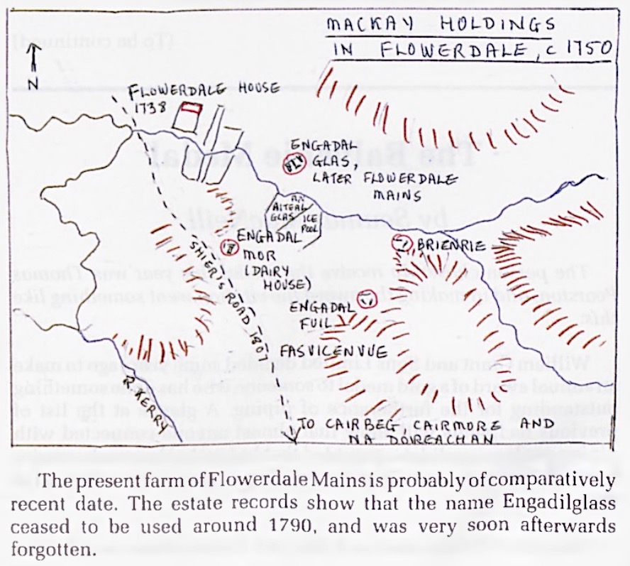
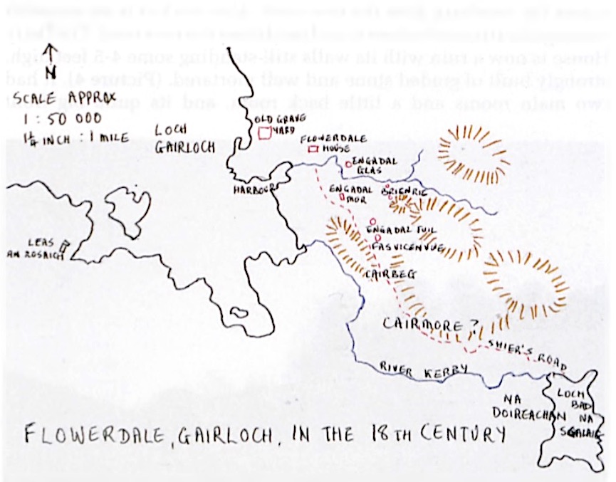
| Of these names of
holdings that Roy Wentworth had found in the
estate records, he was able to identify Cairbeg,
na Doireachan and Fasvicenvue with reasonable
accuracy. Cairmore was clearly close to Cairbeg,
in or near Kerrysdale. But the other four names, Brienrie, Engadalmore, Engadalglass and Engadalffuil, were totally unknown. Brienrie was always listed in the midst of the Engadal names, and it was a fair assumption that Brienrie must lie within the glen of Engadal - but where was Engadal? Engadal is a Norse name which could have either of two interpretations: 1) Norse eng or ong + dal "narrow glen". 0ng is the older form. 2) Norse engi + dal "hay-meadow glen”. (※ 北欧語が正しくに表記できないので、オリジナル誌面確認の事) The earliest spellings in the estate records, from a charter of 1513 with Hoyngildale, through to the of 1673 with tuo oynggidillis, give mainly oyng as the first syllable. This consistency covering 160 years suggests a derivation from ang "narrow", a form which later became eng. The second syllable of Hoynigildale appears four times, up to 1566, and may possibly indicate that the original name was ong-gil- dal "the glen of the narrow ravine". This is by no means certain, as the first example could have been an error, copied by the next three. Neither of these interpretations (1) or (2) above gives a clue as to where Engadal was. It appears frequently in the estate records between 1513 and 1790, when it disappears completely. Already by the middle of the 19th century, in the time of Sir Francis MacKenzie, laird from 1826 to 1843, knowledge of the location of Engadal had been lost, and Engidales in the records was assumed to be an error for Erradale. Dixon (62—3) said it was a place "which has now entirely disappeared", and he believed it to have been at the mouth of the Kerrysdale river. None of his informants in the late 19th century had any idea of the location of Engadal. |
Roy
Wentworth
が地所記録から見つけたこれらの地所名のうち、Cairbeg、na
Doireachan、Fasvicenvue
はそれなりに正確に特定することができた。Cairmore は明らかに Cairbeg
の近く、Kerrysdale の近くであった。 しかし、他の4つの名前、Brienrie、Engadalmore、Engadalglass、 Engadalffuil は全く不明であった。Brienrie は常に Engadal の名前の中に入っており、Brienrie は Engadal の渓谷の中にあるのだろうと考えるのが妥当であったが、Engadal はどこにあったのか。 Engadal は北欧語の名前であり、次の2つの解釈が可能である。 1) 北欧語の eng または ong + dal「狭い渓谷」。0ng の方が古い形式である。 2) 北欧語の engi + dal 「干し草が生い茂る渓谷」。 領地の記録では、1513年の契約状で Hoyngildale、1673年の Retour で tuo oynggidillis と、最も古い綴りは、最初の音節を ong とするものであった。この160年にわたる一貫性は、ang「狭い」が語源であり、後に eng となったことを示唆している。 Hoynigildale の第2音節は1566年までに4回出現しており、元の名前が ong-gil- dal「狭い渓谷のグレン」であったことを示す可能性がある。しかし、最初の例が誤りであった可能性もあり、次の3例が模倣された可能性もあるため、決し て確実ではない。 上記(1)、(2)のいずれの解釈も、Engadal がどこにあったかを知る手がかりにはならない。この地名は1513年から1790年までの間、財産記録に頻繁に登場し、その後完全に姿を消した。 19世紀半ば、1826年から1843年まで領主であったSir Francis MacKenzie の時代には既に Engadal の位置は分からなくなり、記録上の Engidales は Erradale の誤りであるとされた。 Dixon (62-3)は「今では完全 に消滅した」場所であり、Kerrysdale 川の河口であったと考えている。19世紀末の彼の情報提供者の中に、Engadal の場所を知っている者はいなかった。 |
| The Flowerdale glen
has had that name only since 1738, when the 9th
laird, Sir Alexander, built the present house and
gave it the somewhat fanciful English name of
Flowerdale. (He married Janet MacKenzie of
Scatwell in 1730, and Iain Dali's poem on the
occasion of their wedding is one of the six of his
poems still extant.) In the memoirs of Dr John MacKenzie (Pigeon Holes 30), the editor's note 13 says that Sir Alexander himself used the new name assiduously, but the local people did not accept it for some 200 years, continuing to call the house Tigh Dige, or Tigh Dige nan Gorm Leac. The glen was known as the Brae of Gairloch. So Roy found that he had a glen with no name earlier than 1738 - and a glen-name, Engadal, with no glen. It seemed reasonable to bring the two together and assume that Engadal was the old name of the Flowerdale glen. Certainly the meaning "narrow glen" would fit, since it is narrow at the mouth and at the head, below the waterfall. But there was no proof that this glen was indeed Engadal. Roy Wentworth searched all the old maps he could find, but none had these old names, nor the glen in sufficient detail. In the map room of the National Library of Scotland he looked at colour slides of General Wade's Military Survey, the original of which is in the British Museum. This map was made in 1750, and looked promising. The glen was shown in some geographical detail, but other than Flowerdale House which has "Gairloch" beside it, there were no names given. But there were some odd clusters of dots, coloured red, which seemed to represent possible groups of buildings - and there were four of these clusters. He made further enquiry, and discovered that in the British Museum the "Original Protractions" of the Wade maps had also been preserved, the surveys and sketches made in the field which were used to make the final "Fair Copy". He managed to obtain copies of these, and found that the clusters of dots are here very faint and less clearly marked, merely sketched in-but they have NAMES, and they are the very names that Roy had found in the estate papers: Engadal mor, Engadal glass and Brienrie. The last name, Engadalffuil, is not given, and the fourth cluster has no name. By working the two versions side by side, he could bring together the clusters of dots clearly marked on one map with the names given on the other. It was now possible to identify the actual sites in the glen. |
Flowerdale
渓谷がその名を持つようになったのは、1738年、第9代領主 Sir Alexander
が現在の屋敷を建て、 Flowerdale
というやや空想的な英名を付けてからである。(彼は1730年に Scatwell の Janet MacKenzie
と結婚し、その結婚を記念したIain Dallの詩は、現存する彼の6つの詩のうちの1つである。) Dr John MacKenzie の 回想録(Pigeon Holes 30)の編集者注13によると、Sir Alexander 自身はこの新しい名前 を熱心に使っていたが、地元の人々は 200年ほどこの名前を受け入れず、この家を Tigh Dige、または Tigh Dige nan Gorm Leac と呼び続けていたという。渓谷は the Brae of Gairloch(Gairloch の岬)として知られていた。 そこで、Roy は、1738年以前の名 称のない渓谷と、Engadal という名称のない渓谷があることに気がついた。 この2つを合わせて、Engadal が Flowerdale glen の古い名前であると仮定するのは妥当であると思われる。 確かに「狭い渓谷」という意味は、滝の下の口と頭の部分が狭いので、ぴったりだ。しかし、この渓谷が本当 に Engadal であるという確証はない。 Roy Wentworth は、ありったけの古地図を探したが、これらの古名や渓谷の詳細が十分に記載されているものはなかった。 スコットランド国立図書館の地図室で、彼は大英博物館に所蔵されているウェイド将軍の軍事測量のカラース ライドを見た。この地図は1750年に作られたもので、期待できそうだった。 渓谷は地理的に詳しく描かれていたが、Flowerdale House の横に "Gairloch" と書かれている以外、名前はない。しかし、赤色で塗られた奇妙な点の集まりがあり、それは建物の集まりを表 しているようだった。その様な点の集まりは4つあった。 さらに調べていくと、大英博物館にはウェイド地図の「原図」が保存されていることがわかった。これは、現 地で測量やスケッチを行い、最終的に「公正な写し」を作るために使われたものだ。 彼は、そのコピーを手に入れ、点の集まりは、ここでは非常に淡く、はっきりとした印もなく、単にスケッチ されているだけだが、名前が付いており、それは Roy が不動産の文書で見つけた名前そのものであることを発見したのだ : Engadal mor, Engadal glass and Brienrie。 最後の Engadalffuil という名前はなく、4番目のクラスタにも名前はない。2つの地図を並べることで、片方の地図に明記されている点の集まりと、もう片方の地図に記されている 名前を結びつけることができた。これで、渓谷に実際にあった場所を特定することができるようになった。 |
| This was where the
benefits of the 1984 gale became apparent. It is
pure luck that the ground happened to be recently
uncovered at the very time when was at the
Heritage Museum making these discoveries.
Everything had combined to reveal the information
the piping world had long been wanting. Brienrie is shown on Wade's maps to be high in the glen, on the brae where the glen narrows, below the waterfalls. It lies on the south side of, and above, the river, and is the furthest east, and the highest, of all the holdings in the glen. The Original Protraction shows a cluster of buildings on top of a rounded knoll on the north-west flank of the hill known as Meall na h-Inghinn. The cluster on the Fair Copy lies just above the river, a little below and to the north of the position of the other cluster. The Ordnance Survey Grid References are: Site (1) the cluster on the Original Protraction - OS 823747 Site (2) the cluster on the Fair Copy - OS 823748 At both sites, traces of structures are visible: (1) is a circular foundation some six yards across, similar to the site of a prehistoric roundhouse, with what might have been a small rectangular stone construction standing inside it. The site is covered with logs and branch debris from the estate's forest clearance, and the ruins are not clearly visible at the moment (March 1993), but it looks as if an older round building may have fallen into ruin, and the remains of its walls possibly used to shelter a later building there. The site is very exposed, remarkable for its position at the head of the glen, looking down over the whole of Engadal to the sea-but wide open to westerly gales. Site (2) is less well defined. There is evidence above the river, at a point where there are two well-built old stone bridge-buttresses, of vestigial walls and drainage channels. There is a cleared patch in the bracken, about twenty feet long and vaguely rectangular, with aligned stones along one side. This appears to have been a rectangular building lying parallel to the river and about thirty feet above it, possibly with small enclosures around it. A very small burn runs down the hill past the house, and at one point close to the building a hollow has been scooped out beneath a large boulder, to form a primitive well, possibly for watering cattle. The building may have been a steading, or a small house of the butt-and-ben variety. |
1984年の強風の恩恵は、ここで明らかになっ
た。Roy Wentworth
がヘリテージ・ミュージアムでこれらの発見をしている時に、たまたま最近になって地表が現れたというのは、本当に幸運なことであった。パイピング界が長い
間欲していた情報が、すべて重なって明らかになったのである。 Wade の地図によると、Brienrie は渓谷の高台、渓谷が狭まったところの岬、滝の下にある。川の南側と上部に位置し、渓谷にあるすべての所有地の中で最も東にあり、最も高い場所に位置す る。 原画には、Meall na h-Inghinn として知られる丘の北西にある丸い小山の頂上にある建物の集合が描かれている。 公正な写しい描かれている建物群は川のすぐ上にあり、他の建物群の位置より少し下と北にある。 陸地測量局のグリッドレファレンスは以下の通り。 サイト(1) オリジナルの複製にあるクラスター - OS 823747 サイト(2) フェアコピーのクラスター - OS 823748 両方のサイトで、構造物の痕跡を見ることができる。 (1)は、先史時代の円形倉庫のサイトに似た、約6ヤードの円形の基礎で、その中に小さな長方形の石の構 造物が立っていたと思われます。 この遺跡は、領地の森林伐採で出た丸太や枝の残骸で覆われており、現在(1993年3月)、遺跡ははっき りと確認できないが、古い円形の建物が荒廃し、その壁の跡が後の建物のシェルターとして使われていた可能性 がありそうである。 この遺跡は、渓谷の突端に位置し、Engadal 全体を海まで見下ろしながら、西風に大きくさらされる、非常に露出度の高い場所であることが特徴である。 遺跡(2)は(1)よりは明確に確認できていない。 川の上、古い石造りの橋脚が2つある地点に、壁や排水路の痕跡が残っている。蕨の中に伐採された場所があ る。長さ20フィートほどの漠然とした長方形で、片側に石が並んでいる遺跡がある。 これは、川と平行に、約30フィートの高さにある長方形の建物で、おそらくその周りに小さな囲いがあった と思われる。 建物の近くには、大きな岩の下に極めて小さな小川があり、おそらく牛に水をやるための原始的な井戸のよう な形になっている。 この建物は、農業用の建物か、あるいはバット&ベンのような小さな家であったのかもしれない。 |
 |
|
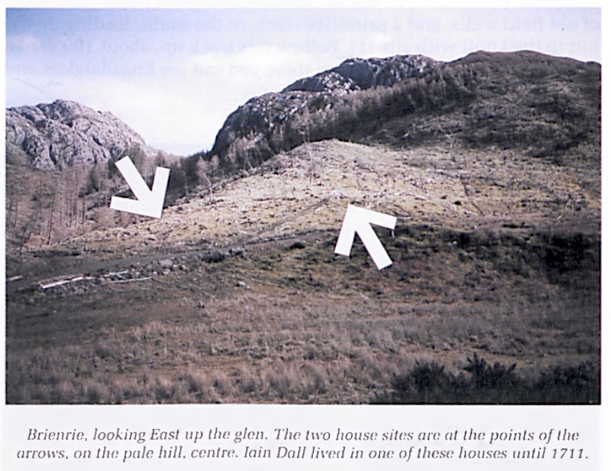
| The records tell us
that there were two small holdings at Brienrie,
and we have no way of knowing which of these two
was Iain Dall's - hut one of them certainly was.
He lived there until 1711. He may have been there
for some time before 1706, when he first appears
in the Tutorial Accounts. He may have been living there in 1696 when he composed his great piobaireachd poem "Corrienessan's Lament"; and this may be the home he set up when he returned from his training in Skye in the 1680's. The date of his marriage is unknown, and so is the name of his wife. There were three children: the eldest, John, whose birthdate is not known, Angus, born c.1723, and a daughter, whose name has been lost, the mother of the Gaelic bard, William Ross. It is possible that Iain Dali married in 1711, and that may have been one reason for his move to Engadilglass. To reach Brienrie : Go up the Flowerdale glen past the big house and past the farm of Flowerdale Mains. Go through the gate on the track for the waterfalls. About a quarter of a mile beyond the gate, another track branches off to the right, crossing the river. Go across this bridge, observing on the left the old buttresses of a former bridge below Brienrie. As soon as you are over the river, look for a temporary estate forest-clearance track on your left, which goes up the south side of the river. This crosses the Brienrie remains (2) and probably obliterates part of them. Most of the remains lie on the upper side of this track. From here you can see the outlines of old fields, and traces of old field walls, and a primitive track, to the south, leading up the hill to the knoll with site (1). Follow this track up, about 100 yards, to find the circular site (1). From there you can see Engadalglass and Engadalmore. |
記録によると、Brienrie
には2つの小さな借地があり、どちらが Iain
Dall のものかはわからないが、片方は間違いなく Iain Dall
のものだった。彼は1711年までそこに住んでいた。Tutorial Accounts
に初めて登場する1706年以前からそこに住んでいたのかもしれない。 1696年に偉大なピーブロック詩 "Corrienessan's Lament" を作曲したときにもそこに住んでいたかもしれないし、1680年代にスカイ島での修行から戻ったときにもこ の家に住んでいたかもしれない。 結婚の時期も妻の名前も不明である。子供は3人で、長男は生年月日不明の John、1723年頃に生まれた Angus、そして名前は失われてしまったがゲール語 吟遊詩人で William Ross の 母になった娘である。 Iain Dall は1711年に結婚した可能性があり、それが Engadilglass に移った理由の一つである可能性がある。 Brienrie への道順: Flowerdale 渓谷を登り、大きな家を過ぎ、Flowerdale Mains の農場を通り過ぎる。ゲートを通り、滝のある小道へ。ゲートを越えて約4分の1マイルのところで、別の小道が右側に分岐し、川を交差する。左手に Brienrie の下にあるかつての橋の古い石積みが眺めながら橋を渡る。 川を渡るとすぐに、左手に川の南側を登って行く一時的な森林伐採のための小道がある。この道は Brienrie 遺跡 (2)を横切り、おそらく遺跡の一部を消している。遺跡の大部分は、この小道の上の方にある。 ここから、古い畑の輪郭、古い畑の壁の跡、原始的な小道が見え、丘の上にある遺跡(1)へと続いている。 この小道に沿って100ヤードほど登ると、円形の遺跡(1)に行き着く。そこからは、 Engadalglass と Engadalmore を見ることができる。 |
 |
|
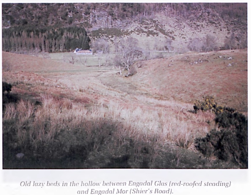
| Engadalglass, or
Engadilglass - the spellings vary in the different
records —is where Iain Dali moved in 1711, and the
present-day farm of Flowerdale Mains is on the
same site. Iain Dali was one of three tenants, all with small holdings of equal size at Engadilglass. He was there at least 11 years, probably longer. The present farm steading probably covers the site of his house. The cluster of houses shown on the Fair Copy of Wade’s 1750 map is a group of buildings close together, possibly sharing farm buildings. Part of the land of the farm today is a field across the river called on the OS map An Aiteal Glas, which is meaningless as a fieldname. Roy Wentworth suggests that it might be a corruption of a local dialect pronunciation of the old name Engadalglass. If so, the name is the sole survivor of the Engadal names. Beside this field is a wedge-shaped piece of wet ground formerly used by the estate as an ice-pool. In the late 18th century, a burn was diverted when frosty weather was expected, and this ground was flooded. When the ice was thick, it was cut in blocks and taken down the glen for storage in the ice-house (still visible between Flowerdale House and the main road, on the north side of the glen road). It is possible that the name Engadalfuil (Engadal a'Phuill, "Engadal of the Pool") is named after this pool, although it is on the land of Engadalglass. Engadalfnil lies on higher ground on the south side of the main glen, on the same burn that was used to feed the ice-pool. |
Engadalglass または
Engadilglass(記録によって綴りが異なる)は、1711年に Iain Dall が移り住んだ場所で、現在の
Flowerdale Mains の農場は同じ場所にある。 Iain Dall は3人の借主の一人 で、全員が Engadilglass に同規模の小さな借地を借りていた。少なくとも11年間、或はもっと長い間そこにいた。 現在の農業用建物は、おそらく彼の家の跡地である。ウェイドの1750年版地図の公式な写しに描かれた家 屋群は、近接した建物群であり、おそらく(この3人が)農 場の建物を共有していたものと思われる。 現在のこの農場の一部は、OSの地図では An Aiteal Glas という川を挟んだ畑になっているが、これは畑の名前としては意味がない。Roy Wentworth は、古い名前 Engadalglass の地元方言の発音が訛ったものではないかと指摘しています。もしそうなら、この名前は Engadal の名前の唯一の生き残りである。 この畑の横には、かつて領地が製氷池として使っていたくさび形の湿地がある。18世紀後半、霜が降りると 予想されたときに、小川を迂回させ、この地に水を張った。氷が厚くなると、氷を塊に切り出して渓谷に運び、 氷室(現在も Flowerdale House とメインロードの間、渓谷沿いの道の北側に見える)に貯蔵していた。 Engadalfuil(Engadal a'Phuill, "Engadal of the Pool")という名前は、Engadalglass の土地にありながら、この(製氷)池にちなんで名付けられた可能性がある。Engadalfnil は主な渓谷の南側の高台に位置し、製氷池に水を引くために使われたの小川の上にある。 |
 |
|
| The present farm of
Flowerdale Mains is probably of comparatively
recent date. The estate records show that the name
Engadilglass ceased to be used around 1790, and
was very soon afterwards forgotten. From the estate records we may deduce that until about 1600, the only Engadal name was that of the glen itself. Then the charters begin to mention "two Engadals", which in 1616 are named as Mekle Angedaill (Engadal mor) and Angedaill phoill (Engadal a'phuill). These are the first occurrences of the names. In 1678 reference is made to "three Engidales", and in 1704 the three are named as Engidale more (a quarter land), Engidale fuile (three pecks) and Endilie (sic) glas (three pecks). Evidently this last was a clerical error for Engidale glas, the first time this name is given. In 1706, Brienrie is named for the first time, with John Pyper as one of its two tenants. All four names then appear regularly until 1789, but the Rentals of 1790 onwards have no mention of any Engadal name, nor of Brienrie. To reach Engadalglass: Go up the glen road from the main road, past Flowerdale House. Follow this road to the farm called Flowerdale Farm or Flowerdale Mains. This is the site of Engadalglass until the 1790's. The exact position of the three houses here is not known. Both Brienrie and Engadal more can be seen from here. |
現在の Flowerdale Mains
の農場は、おそらく比較的新しいものであろう。領地の記録によると、Engadilglass
という名前は1790年頃に使われなくなり、その後すぐに忘れ去られたようである。 領地記録から推測すると、1600年頃までは Engadal の名称は渓谷自体の名称だけであったようである。その後、"two Engadals" と表記される様になり、1616年には、Mekle Angedaill(Engadal mor)と Angedaill phoill(Engadal a'phuill)と命名されたのである。この名前が初めて登場したのはこの時である。 1678年には "three Engidales" に言及し、1704年には この3つは Engidale more(a quarter land)、Engidale fuile(three pecks)、 Endilie (sic) glas (three peck)と命名している。この最後の名前は、明らかに Engidale glas の事務的なミスであり、この名前が最初に与えられたものである。 1706年には、Brienrieの名が初めて記され、John Pyper が2人の借主の1人として名を連ねている。その後1789年まで4つの名前が恒常的に登場するが、1790年以降の Rentals には Engadal の名前も Brienrie の名前も出てこない。 Engadalglass への道順: メインロードからグレンロードを登り、Flowerdale House を過ぎる。この道を進むと、Flowerdale Farmまたは Flowerdale Mains と呼ばれる農場に出る。ここが1790年代まで Engadalglass のあった場所である。ここにあった3軒の家の正確な位置はわかっていない。ここからは、Brienrie と Engadal more の両方が見える。 |
| Part3 【Vol.46/No.4-1994 /2-P17】 |
|
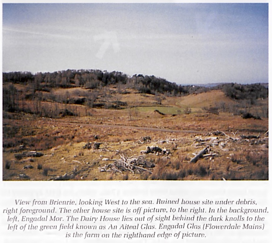
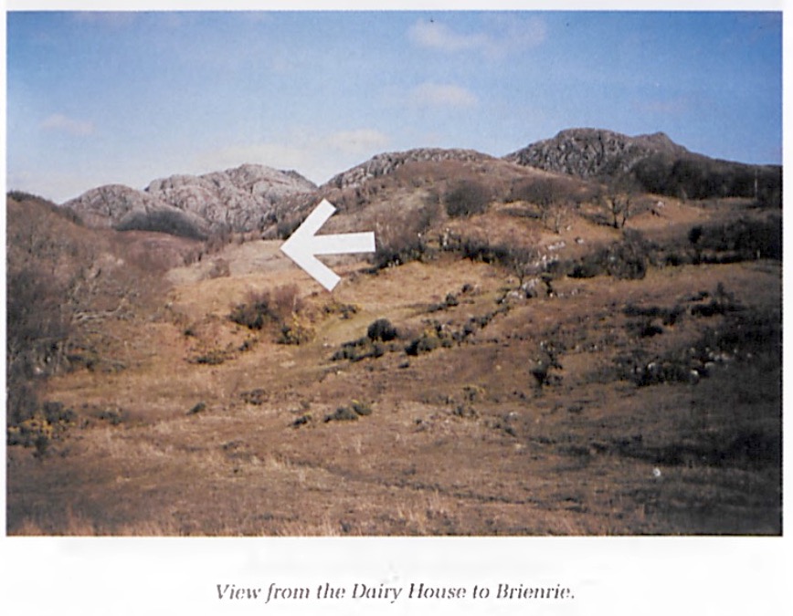
| Engadalmore was, as
the name suggests, a large holding of land, a full
quarterland in extent. The house belonging to the
holding seems to have been to the S.E. of
Flowerdale House and across the river, up a small
tributary burn which enters the river opposite to
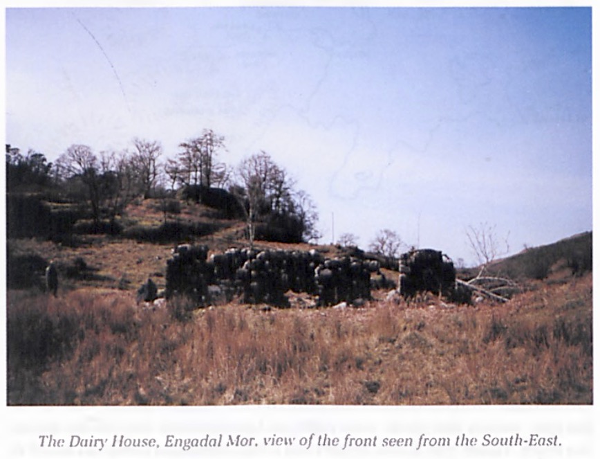
Flowerdale Mains. A map made by Thomas Shier in 1807, showing the route of his new road through the estate - which now exists as an estate track - shows a building with the name, The Dairy House, across the wee burn from the new road. Also marked is an unroofed rectangular structure, close to and just below the new road. The Dairy House is now a ruin with its walls still standing some 4-5 feet high, strongly built of graded stone and well mortared. (Picture 4). |
Engadalmore
はその名の通り、1/4ランドの広さを持つ大きな土地であった。Flowerdale House
の南東、川を渡り、Flowerdale Mains
の向かいで川に入り込む小さな小川の支流を登ったところに、この土地に建つ家があったようだ。 1807年に Thomas Shier が作成した、この領地を通る新しい道路のルート(現在は領地内の小径として存在)を示す地図には、新しい道 路から小さな小川を渡ったところに、The Dairy Houseと名付けられた建物が記されている。 また、新しい道のすぐ近くの下に、屋根のない長方形の建物も記されている。Dairy Houseは現在廃墟となっているが、高さ4〜5フィートの壁が残っており、勾配のある石で頑丈に造られていて、よくモルタルで固められている。(写真 4)。 |
 |
|
| It had two main rooms
and a little back room, and its quite big front
windows looked out towards Brienrie to the N.E.
This may have at one time been the dairy or
"manufactory" referred to by Dr John MacKenzie in
his Memoirs (Pigeon Holes 36): he says that
in his boyhood the cows were milked "within eighty
yards of the Chateau", and the dairy "was then a
projecting wing of Tigh High". Does his use of the word "then” simply imply that it used to be elsewhere? His boyhood was in the earliest years of the 19th century, the very time of Shier's map. So was the Dairy House ever used as a dairy, or does the name mean something else? And before this time, was this the site of the house belonging to Engadalmore? A Comprisement of 1785 (Conon House Archives 5/104) lists all the structures-buildings and stone walls - on the estate; it ends with "Engdal more house". No dairy building is named. Engadal more was a quarterland reaching over the hill to Kerrysdale, and in 1766 it included the land of Cairmore. Angus MacKay held Cairmore, but he does not seem to have lived in the house at Engadalmore. The OS Grid Reference for the Dairy House is 818748. |
2つのメインルームと小さなバックルームがあ
り、かなり大きな正面の窓からは北東の方角に Brienrie 方面が見渡せる。この場所は、Dr John MacKenzie の回想録
(Pigeon Holes
36)で言及していた、搾乳所、または「製造所」だった可能性がある。彼が言う所では、少年時代には「シャトーから80ヤード以内」で牛の乳搾りが行われ
ており、搾乳所は「当時は Tigh High の突き出た翼」だったと述べている。 彼が使ったこの「当時」という言葉は、以前は別の場所にあったということを意味しているのだろうか? 彼 の少年時代は19世紀の初期で、まさに Shier の地図の時代である。では、Dairy House は搾乳所として使われていたのだろうか、それとも別の意味があるのだろうか? そして、それ以前は、ここが Engadalmore に属する建物の敷地だったのだろうか? 1785年の Comprisement (Conon House Archives 5/104) には、領地内のすべての建造物、石垣がリストアップされており、"Engdal more house" で締めくくられている。酪農家の建物は記載されていない。 Engadal more は丘を越えて Kerrysdale まで続くクォーターランドで、1766年には Cairmore の土地も含まれていた。Angus MacKay は Cairmore を所有していたが、Engadalmore の家屋には住んでいなかったようである。Dairy House のOS Grid Reference は818748である。 |
 |
|
| To reach Engadalmore
(the Dairy House): Go up the glen road past Flowerdale House, as far as the farm of Flowerdale Mains. Just before the gate across the track, turn right and go down to the bridge across the river. When you have crosed the river, there is a steepish knoll in front of you, to the south. Pass round this to the right (west) and behind it is the ruined Dairy House. It is shown on the OS 1:25 000 map, as a ruin. Across the burn, up the hillside to the W. among the trees, is the line of the new road of 1807, as shown on Shier's plan. Across the burn is the Shier road, now an estate track, up on the hillside. Just below it is the rectangular enclosure, marked by thick stone walls, now in ruins. A large tree has fallen across it. This was possibly an enclosure for milking cows or for penning their calves during milking. Or it may have been a garden. Engadalfuil seems, from the unnamed cluster shown on the original protraction of the Wade map, to have been on the burn called "Allt a 'Gharbh Airigh", in the area of OS Grid Reference 822742. This is only a few hundred yards north of Fasvicenvue (Faich Mhic Eoin Bhuidhe) which John Roy MacKay held with Engadal fuil in 1780. |
Engadalmore (Dairy
House)への道順 Flowerdale House を過ぎ、Flowerdale Mains の農場まで峡谷道路を上る。小径を横切るゲートの手前で右折し、川を渡る橋まで下る。川を渡ると、目の前に南向きの急な丘がある。これを右(西)に回り込 むと、その奥に廃墟となった Dairy House がある。これはOS 1:25 000 map に廃墟として記載されている。小川を渡り、西の丘陵を登ると、木々の間に1807年の Shier の地図に示されている新しい道路がある。 小川を渡って丘の中腹に上るのが Shier に示されている道路で、現在は領地の小径になっている。そのすぐ下には、分厚い石垣に囲まれた長方形の囲いがあるが、今は廃墟になっている。大きな木が横 切って倒れている。これはおそらく、搾乳用の牛か、搾乳中の子牛を囲うための囲いであったのだろう。あるい は、庭だったのかもしれない。 Engadalfuil は、Wade 地図のオリジナルの縮図に示された名の無いクラスターから、OS Grid Reference 822742のエリアにある "Allt a 'Gharbh Airigh" と呼ばれる小川の上にあったようだ。この場所は、1780年に John Roy MacKay が Engadal fuil と共に所有していた Fasvicenvue(Faich Mhic Eoin Bhuidhe)から北方向に僅か数百ヤードしか離れていない場所である。 |
 |
|
| Iain Dall was probably
living at Engadalglass in 1723 when his son Angus
was born, and also when he heard the (false) news
that his teacher Patrick Og MacCrimmon was dead
and composed the great lament for him. The bulk of his greatest work, in music and in poetry, would have been made there - although during this period he was often away on his travels, visiting castles and great houses to augment his living by performances to the wealthy and influential. Dixon (178) and others have said that he went travelling when he was an old man in retirement, but the dating of his poems and some of his pipe music makes it clear that he was making frequent visits to the Munros at Foulis, the MacDonalds at Duntulm and the MacKays in Tongue from the 1690's on. Probably the prolonged absences of the Gairloch lairds made it necessary for him to augment his income by composing and performing for other patrons. Because of the 30-year gap in the estate rentals between 1722 and 1752, we do not know how long Iain Dall stayed at Engadalglass. It seems that in his old age, after his son Angus had taken over as piper to the laird, he moved away from Engadal. Dixon (173) says that he "retired when in advanced years, and Sir Alexander allowed him a sufficient pension". This may have included a house, for there is a local tradition that he went to live on the west side of Badachro, a small harbour on the south shore of Loch Gairloch. |
Iain
Dall は、息子の Angus
が生まれた1723年、そして、師匠の Patrick
Og MacCrimmon
が亡くなったという(嘘の)知らせを聞き、彼のために偉大なラメントを作曲したときにも、おそらく
Engadalglass に住んでいたものと思われる。 この時期、彼はしばしば旅に出て、城や豪邸を訪れ、裕福な人々や有力者のために演奏して自身の生活の糧 にしていた。音楽と詩における彼の偉大な作品の大部分は、ここで作られたものであろう。 Dixon (178)などは、彼が引退後の老人になってから旅に出たと述べているが、彼の詩やいくつかのパイプ・ミュージックの年代から、1690年代から Foulis の Munros 家、Duntulm の MacDonalds 家、Tongue の MacKays 家を頻繁に訪問していたことは明白である。 おそらく Gairloch の領主の長期不在のため、他の後援者のために作曲や演奏をすることで収入を増やす必要があったのだろう。 1722年から1752年までの 30年間は地所賃貸の空白期間があるため、Iain Dall が Engadalglass にいつまで住んでいたかは不明である。老齢になり、息子の Angus が領主のパイパーとして役割を引き継いだ後、Engadal から離れたようである。 Dixon (173)によれば、彼は「高齢になってから引退し、Sir Alexander は彼に十分な年金を与えた。」とある。これには家も含まれていたのだろう。地元の言い伝えによれば、彼は Loch Gairloch の南岸にある小さな港、Badachro の西側に住んだという。 |
 |
|
| This small house was
on the Aird road, and overlooked the harbour.
Some, however, say that this was his daughter's
house, and that the old piper had a cottage beside
the road between Shieldaigand Badachro. Hlis daughter married a man from Skye, John Ross, and their son was William Ross, who inherited his grandfather's poetic genius. The Ross family lived in the house on the Aird road, which was known locally as "Leas an Rosaich" - "The Ross man's Garden" -this refers to John Ross, the son-in-law of Iain Dall, rather than his grandson William. Whether the old piper went to live with his daugher and son-in- law, or whether his daughter inherited the house after his death in 1754, we do not know - if indeed this was the house where he lived at all. William Ross was born in Skye in 1762, which suggests that the Rosses came to Badachro later. William in adult life returned to the house when he became a teacher and catechist in Gairloch. He died young from T.B. in 1791. For years, all that was to be seen at Leas an Rosaich was the walled enclosure of the former garden, until recently the foundations of the house beside it were uncovered, on the north side. It is a small rectangular foundation of a house of the butt-and-ben type. It lies NW-SE, gable-end to the road. There are different versions of a local story about the old piper when he was living near Badachro. If a funeral procession was passing the house, led by a piper, he would come to the roadside as a mark of respect for the dead, as custom demanded - but if the piping was poor, he would put his hands over his ears, as the piper went by. This story has received the embroidery of time, and the version changed : the pipers became embarrassed, it was said, by the presence of the old man who had been such a great player, so they stopped playing altogether as they passed his house. It became such a custom to stop the pipe as his house was passed that they continued to do it even after his death. This gave rise to a belief that the house was haunted by the ghost of the Blind Piper, and no-one would live there, and so the house fell into ruin ... this might have been true of a house on the lower road, but if it refers to Leas an Rosaich, it takes little account of the Ross family who were there after him. When William died in 1791, he was unmarried and there was no family left to inherit the place : his uncle, Angus MacKay, had died before 1780, his other (putative) uncle. John, had probably gone to Nova Scotia in 1773, and his cousin John Roy was soon to join him there. There were no descendants left in Gairloch to live in the house. John G. Gibson of Nova Scotia (MacLennan JG) has shown that Angus had a daughter who married one of the piping MacLennans, a forebear of G.S. and D.R. MacLennan. After various adventures their son Roderick was forced to change his name, and he took his mother’s maiden name, MacKay, when he was living in Nova Scotia, not far from where his uncle, John Roy, had settled. This relationship by marriage would not have been strong enough to give the MacLennans a claim to the house. John MacLean, late Rector of Oban High School, in his paper to the Gaelic Society of Inverness (April 1952) tells a story he heard in Raasay as a boy : when John Roy left Gairloch in 1805, taking with him all his large family except one married daughter, he seems to have been pessimistic about piping in the Highlands. As he was rowed out to the "Sydney Smith" anchored off the island of Longa, he was playing a piobaireachd which nobody recognized. Asked for its title, he said it was called "The Departure of Piping from Scotland". He was mistaken. It turned out to be a lament for the departure of piping in the MacKay family. They had come to Gairloch from Strathnaver just under two hundred years earlier, and their history had been tied up with that of the MacCrimmons in Skye. Iain Dall, the Blind Piper of Gairloch, represented the heights to which the family could reach, in music and in poetry. Within two generations of their settling in Nova Scotia, the MacKays were no longer pipers. |
この小さな家は Aird
街道沿いにあり、港を見下ろすことができた。しかし、これは彼の娘の家であり、老いたパイパーは
Shieldaig と Badachro の間の道のそばにコテージを持っていたという説もある。 彼の娘はスカイ島出身の John Ross と結婚し、その息子が William Ross で、彼は祖父の詩の才能を受け継いだ。Ross 一家は Aird 街道沿いの家に住み、地元では "Leas an Rosaich" - "The Ross man's Garden "として知られていたが、これは孫の William ではなく、Iain Dall の義理の息子である John Ross のことを指している。 老いたパイパーが娘や婿と暮らしたのかどうか、1754年の彼の死後に、娘がこの家を受け継いだのかはど うか、も分からない。そもそも、この家は本当に彼が住んでいた家なのだろうか。 William Ross は1762年にスカイ島で生まれているので、Ross 家が Badachro に来たのはその後と思われる。成人した William は、Gairloch で教師&牧師となり、この家に戻ってきた。1791年に若くして結核で亡くなっている。 Leas an Rosaich では長年、かつての庭の塀で囲まれた部分しか見ることができなかったが、最近になって北側にあった家の基礎が発見された。この建物は、長方形の小さな「突 き合わせ型」住居の基礎である。北北西に位置し、切妻側が道路に面している。 老いたパイパーが Badachro の近くに住んでいたころの地元の伝承には様々な言い伝えがある。 パイパーに先導された葬列が家の前を通る時、彼は死者への敬意を表するために道端に出向くが、パイパーの 演奏が貧弱なものであった場合、彼は両手を耳に当ててパイパーが通り過ぎるの待ったと言う。 この言い伝えは、時を経ると尾ひれがついてバージョンが変化していく。パイパーたちは、さしもの偉大なパ イパーを前にして演奏するのは恥ずかしいと感じ、行進する際に家の前を通り過ぎるまでパイプを止めるという 風習が続いた、と言われている。 そして、彼の死後もパイパーたちが彼の家の前でパイプを止める事が慣習となった。 この慣習のため、この家には Blind Piper の幽霊が出ると信じられる様になり、その後は誰も住まなくなり、家は廃墟となった。…これは下の道の家にも当てはまるかもしれないが、これが Leas an Rosaich を指しているとすれば、彼の死後にそこに住んだ Ross 家のことはほとんど考慮されていないことになる。 1791年に William が亡くなった時、彼は未婚で、この場所を受け継ぐ家族はいなかった。彼の叔父である Angus MacKay は1780年以前に亡く なっており、彼のもう一人の(と思われる)叔父 John MacKay は1773年にノバスコシアに渡り、従兄弟の John Roy もすぐに彼に加わったと思われる。この家に住む子孫は Gairloch には残っていなかった。 ノバスコシアの John G. Gibson(MacLennan JG)は、Angus には娘がいて、その娘は G.S. と D.R. MacLennan の先祖であるパイピ ング一家 MacLennan 一族の 一人と結婚し たことを示している。彼らの息子 Roderick は様々な冒険の末に改名を余儀なくされ、叔父の John Roy が定住した場所からそう遠くないノバスコシアに住んでいた時に、母親の旧姓で ある MacKay を名乗るようになった。この婚姻による関係は、MacLennan 家にこの家の所有権を与えるほど強いものではなかっただろう。 オーバン高校の元学長 John MacLean は、インバネスのゲール語協会に寄せた論文(1952年4月)で、少年時代に Rassay で聞いた話を紹介している。John Roy が1805年に結婚していた娘一人を除く大家族全員を連れて Gairloch を離れた時、彼はハイランドでパイピングすることに悲観的だったという。 Longa 島の沖に停泊していた「シドニー・スミス号」に漕ぎ出されたとき、彼は誰も知らないピーブロックを演奏していた。タイトルを聞かれた彼は、「スコットラン ドからのパイピングの旅立ち」だと答えた。しかし、それは違っていた。それは、MacKay 一家のパイピングの旅 立ちに関するラメントである。 彼らは200年近く前に Strathnaver から Gairloch にやってきて、その歴史はスカイ島のマクリモン一族の歴史と結びついていたのである。The Blind Piper of Gairloch、Iain Dall は、音楽と詩において、この一族が到達した高みを象徴する存在であった。 ノバスコシアに移住してから2世代も経たないうちに、MacKay 家はパイパーの一族ではなくなってしまった。 |
| Note I would like to express my thanks to Roy Wentworth for making his findings freely available to me, and for encouraging me to write this article in view of the interest of his material to the piping world. My husband Alex and I joined him on expeditions to Engadal, and helped to find ruins and identify the different sites, but all the preliminary work was his, and the material published here was uncovered by him alone. |
備考 Roy Wentworth には、彼の研究成果を自由に利用できるように許可してもらえた事、また、彼の資料がパイピング界にとって興味深いものであることを考慮し て、この論文を書くように促してくれた事に感謝の意を表したい。 夫の Alex と私は、彼の Engadal 探検に参加し、遺跡の発見や遺跡の特定を手伝ったが、事前の調査はすべて彼が行い、ここに掲載した資料も彼一人で発掘したものである。 |